How far away is the sea?
I wanted an app to answer this question, so I wrote one:
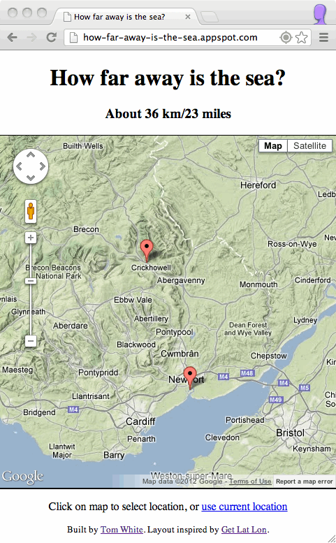
You can try it out at http://how-far-away-is-the-sea.appspot.com/. It works well on phones too, so you can use it when you are out and about.
The app uses your current location (or a location you selected by clicking on the map) and computes the closest point in the set of land polygons. This calculation is performed using the JTS Topology Suite, a library for 2D spatial work, and it runs as a Java webapp hosted on Google App Engine.
Originally I used Geotools to perform the geospatial calculations, but unfortunately it doesn't run on GAE, so I wrote an offline tool to convert the Natural Earth shapefiles to a JTS binary format. JTS works fine on GAE, but it lacks a distance calculator. Luckily spatial4j has the requisite distance functions, and it too works on GAE.
The webapp exposes a simple query endpoint, so a request for the following URL, for example:
http://how-far-away-is-the-sea.appspot.com/query?lat=51.856479&lng=-3.13551
will return a JSON document with the closest point on the coast, whether the (origin) location is on land or at sea, and the distance in metres to the coast:
The page that the user sees is a simple static HTML page that uses the Google Maps API (v3) to render the map and the markers, and jQuery to query the Java webapp.
The complete source code is on Github at https://github.com/tomwhite/how-far-away-is-the-sea.
It would be interesting to use the dataset to answer the question: "which is the furthest point from the sea [in the UK/in X/in the world]?". I'd like to find time to do that sometime. Adding in spatial indexes might be helpful too.
You can try it out at http://how-far-away-is-the-sea.appspot.com/. It works well on phones too, so you can use it when you are out and about.
How does it work?
I used the dataset of land polygons from Natural Earth, which as the name suggests covers the whole world. The scale is 1:10 million, so inevitably there is some inaccuracy near the coast, particularly where it's wiggly.The app uses your current location (or a location you selected by clicking on the map) and computes the closest point in the set of land polygons. This calculation is performed using the JTS Topology Suite, a library for 2D spatial work, and it runs as a Java webapp hosted on Google App Engine.
Originally I used Geotools to perform the geospatial calculations, but unfortunately it doesn't run on GAE, so I wrote an offline tool to convert the Natural Earth shapefiles to a JTS binary format. JTS works fine on GAE, but it lacks a distance calculator. Luckily spatial4j has the requisite distance functions, and it too works on GAE.
The webapp exposes a simple query endpoint, so a request for the following URL, for example:
http://how-far-away-is-the-sea.appspot.com/query?lat=51.856479&lng=-3.13551
will return a JSON document with the closest point on the coast, whether the (origin) location is on land or at sea, and the distance in metres to the coast:
{"latitude":51.856479,
"longitude":-3.13551,
"coastLatitude":51.55853913000007,
"coastLongitude":-2.984038865999878,
"onLand":true,
"distanceToCoast":34734.59501052392
}
The page that the user sees is a simple static HTML page that uses the Google Maps API (v3) to render the map and the markers, and jQuery to query the Java webapp.
The complete source code is on Github at https://github.com/tomwhite/how-far-away-is-the-sea.
Further ideas
Some of the polygons are a poor approximation to the coastline, so it would be nice to get a higher-resolution dataset. There are likely many potential sources, such as this one for the UK.It would be interesting to use the dataset to answer the question: "which is the furthest point from the sea [in the UK/in X/in the world]?". I'd like to find time to do that sometime. Adding in spatial indexes might be helpful too.